
Collecting Data Before Drilling Begins
Geophysics can help to answer these questions:
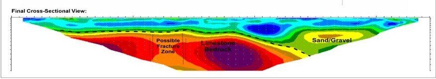
- How far does the sand and gravel extend to the north?
- Does the aquifer get deeper or shallower as we move west?
- Can we refine the location of a fracture in the bedrock that we saw on an aerial photograph?
Drilling
in fractured bedrock can be a frustrating process – if the fracture is not open and productive. The geophysical survey provides a variety of tools to either perform preliminary analysis of a very large area or to take a detailed look at a very small area. Often, when a system is looking for a new well field, a broad look at several areas is faster and less expensive, and can provide information on where NOT to do additional research.